‘Standby, Safety. We’re making the move . . .’
The voice from the control room is steady, practiced, confident, unhurried. Outside, a small observatory-like dome begins to rotate, gliding smoothly and quietly on well-oiled gears.
“OK, we’re tracking, Safety. Are you guys good?”
Dave Denning (5737), surrounded by a suite of rack-mounted instruments and glowing LCD monitors, speaks into his headset mike, querying his team: Safety. Laser. Telescope.
One by one, they report back. “We’re good.”
Tonight, the group is firing a high-powered laser beam through the atmosphere, illuminating the optical sensors on a GPS Block II satellite in a semisynchronous orbit some 12,500 miles above the Earth.
As members of Sandia’s LAZAP (Laser Applications) team, this night they’re going through a process that has been played out thousands of times over the past 30-plus years.
Supporting the test ban treaty
Sandia’s LAZAP program was started in the mid-1970s to test and calibrate the optical sensor systems aboard America’s Vela reconnaissance satellites. The Vela constellation was launched over a period of several years in the 1960s and 1970s to detect atmospheric nuclear detonations. It was part of a suite of technologies designed to monitor compliance with the 1963 Limited Test Ban Treaty, which forbade signatory nations from conducting above-ground nuclear tests.
By sending out bright laser pulses, LAZAP helped Vela controllers confirm that their satellites were, indeed, detecting bright optical events. LAZAP’s laser flashes also enabled mission operators to periodically calibrate the Vela sensors in orbit.
Here’s how it worked: LAZAP operators found and tracked a Vela satellite. (In the early days, this process was done visually and manually using a powerful telescope; today the tracking is computer-controlled.)
Once the target Vela was confirmed, the LAZAP team fired a laser at the satellite, illuminating its optical sensors, which were optimized to pick up ultrabright, ultrafast flashes of light — the kinds of flashes that might characterize a nuclear blast.
Modern systems still need to be calibrated
Since the LAZAP laser was being fired from a known location with known coordinates, testers could calibrate the sensors by comparing that known location with where the Vela satellite “thought” it saw the event. If, for example, the Vela thought the pulse of laser light was coming from, say, the vicinity of Amarillo, when it actually originated in Albuquerque, controllers could build in a compensation factor. That kind of precision would be vital in pinpointing the location of a treaty violation.
The process was not unlike zeroing in the sights on a rifle, getting the crosshairs on the scope to correspond to where the bullet actually hits the target.
The Vela constellation was replaced in the 1980s by the Defense Support Program (DSP) satellites and in the 1990s by the Global Positioning System (GPS) constellation. Both the DSP satellites and the modern GPS satellites still carry optical sensors. And even though they are more advanced, capable, and sensitive than Vela-era sensors, they must still be tested and calibrated much the same way their Vela forebears were.
That’s why, on multiple dark, clear nights each year, the LAZAP team is still working late, tracking, locking on to, and laser-illuminating the latest generation of satellites that make up the space-borne component of the nation’s nuclear detonation (NUDET) detection system.
‘Ready to let the ruby out’
Tonight, the dome has stopped its rotation, its open slot aimed toward a point in the southeastern sky.
In his headset, Dave, who for the past several years has been the LAZAP project lead, is getting reports from his two visual aircraft observers and his radar controller. (The radar controller is working from a feed provided by a local FAA air traffic control center.) Visual and radar agree: The sky is clear. No aircraft are in the vicinity.
Dave glides effortlessly on his wheeled office chair from one side of the control station to the other, checking data on an LCD monitor. It’s a chart displaying so-called predictive avoidance data; that is, windows of time when LAZAP will not inadvertently illuminate nontargeted satellites. It’s the space-based equivalent of making sure no aircraft are nearby. A quick check confirms: The window is open.
With everyone good to go, Dave says into his headset: “Team, I’m going to start shooting the ruby [laser]. I’m going to let the ruby out now.” He counts down, “Five, four, three, two, one . . .”
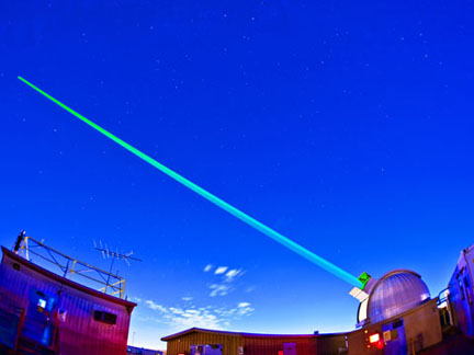
A green light shoots from the dome
Outside, quick red flashes light up the slot in the dome. The Class 4 ruby laser is being pumped through a Cassegrain telescope beam director, which pinpoints the beam onto the target satellite.
Then, more dramatically, a green light shoots from the dome, its pulsating, concentrated beam slicing the sky and visible all the way to the very edge of the atmosphere. Dave explains, “Right now, we do all our calibration testing with the ruby laser, but there are some potential advantages to using the green laser, so we’re doing some testing with it tonight.”
While the test is going on, Victor Chavez (5737), the team’s laser guru, comes in to tell Dave the laser may be on the verge of failing. That’s something that happens periodically and something the team is ready to deal with. Tonight, though, the laser holds up and the data collection is good. Meanwhile, as the test proceeds, Gus Rodriguez (5737), who maintains the LAZAP electronics suite, is busy keeping the system up and running. Debra Yzquierdo-Trujillo (5737) is on the radar board, monitoring air traffic, while the visual safety team outside continues to scan the skies.
Placing the test on hold
Just as Dave is emphasizing that every member of the team can stop the laser firing at any time, he gets a call on his headset and an alert on the status board: One of the visual observers has put a hold on the test as an aircraft appears to be headed toward the quadrant of the sky where the laser is aimed. After a couple of minutes, the sky is clear again, Dave initiates another countdown. The test resumes and continues until the target GPS satellite moves below the horizon.
Later, Dave says the previous night’s tests gathered important data that will be useful in calibrating the spacecraft’s optical sensor. With a constellation of more than 30 GPS satellites and with a number of DSP satellites still being used for NUDET applications, the LAZAP team has a busy and demanding schedule.
Throughout its 35-year history, LAZAP’s primary customers have been the US Air Force NUDET Detection System Program, which owns the satellite platforms that carry NUDET sensor technologies and the NNSA Office of Nonproliferation Research and Development (NA-22) and its predecessors in the Department of Energy. And as space-based optical sensor technology evolves — as will be the case with the upcoming GPS Block III constellation — LAZAP will evolve to provide the necessary calibration and testing protocols.
And, says Dave, “As long as there are optical sensors on board American satellites, we’ll have an essential mission.”