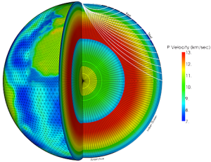
A GeoTess model is comprised of 2D triangular tessellations of a unit sphere with 1D radial arrays of nodes associated with each vertex of the 2D tessellations. Variable spatial resolution in both geographic and radial dimensions is supported. Users have considerable flexibility in how to define the data stored on the grid.
The GeoTess library is provided in Java and C++, with a C interface to the C++ library. The most recent release has been tested on Linux, with Mac and Windows versions coming soon. Source code and pre-compiled binaries are provided.
Version 2.6.1 Software Downloads
Java
C++ / C
Makefiles are included so that any downloaded package can be recompiled for another platform. See the documentation for more information.
Online Documentation
User’s Manual – A PDF file describing the software
Detailed interface documentation – Java C++ C
Example Applications
The following links display html representations of source code for several example applications that use the GeoTess library to accomplish common tasks. The software downloads described above include the source code and compiled binaries for these sample applications.
Registration
Please register (or unregister) by sending an email to: acconle@sandia.gov
Registration is optional, but registered users will be notified of software updates and other noteworthy events related to GeoTess development.
Software License
Copyright 2009 Sandia Corporation. Under the terms of Contract
DE-AC04-94AL85000 with Sandia Corporation, the U.S. Government
retains certain rights in this software.

BSD Open Source License.
All rights reserved.

Redistribution and use in source and binary forms, with or without
modification, are permitted provided that the following conditions are met:

   * Redistributions of source code must retain the above copyright notice,
     this list of conditions and the following disclaimer.
   * Redistributions in binary form must reproduce the above copyright
     notice, this list of conditions and the following disclaimer in the
     documentation and/or other materials provided with the distribution.
   * Neither the name of Sandia National Laboratories nor the names of its
     contributors may be used to endorse or promote products derived from
     this software without specific prior written permission.

THIS SOFTWARE IS PROVIDED BY THE COPYRIGHT HOLDERS AND CONTRIBUTORS "AS IS"
AND ANY EXPRESS OR IMPLIED WARRANTIES, INCLUDING, BUT NOT LIMITED TO, THE
IMPLIED WARRANTIES OF MERCHANTABILITY AND FITNESS FOR A PARTICULAR PURPOSE
ARE DISCLAIMED. IN NO EVENT SHALL THE COPYRIGHT HOLDER OR CONTRIBUTORS BE
LIABLE FOR ANY DIRECT, INDIRECT, INCIDENTAL, SPECIAL, EXEMPLARY, OR
CONSEQUENTIAL DAMAGES (INCLUDING, BUT NOT LIMITED TO, PROCUREMENT OF
SUBSTITUTE GOODS OR SERVICES; LOSS OF USE, DATA, OR PROFITS; OR BUSINESS
INTERRUPTION) HOWEVER CAUSED AND ON ANY THEORY OF LIABILITY, WHETHER IN
CONTRACT, STRICT LIABILITY, OR TORT (INCLUDING NEGLIGENCE OR OTHERWISE)
ARISING IN ANY WAY OUT OF THE USE OF THIS SOFTWARE, EVEN IF ADVISED OF THE
POSSIBILITY OF SUCH DAMAGE.
SAND2020-11075W