Much has been asked of Sandians from the very beginning. Since its founding in 1949, the Labs’ extraordinary mission work has required researchers to travel to the far ends of the world to test nuclear weapon components in every conceivable environment. Over the years, that has meant weeks — and even months — away from home, living in tents in remote locales ranging from jungles to deserts to frozen steppes to tropical isles.
While exotic travel related to weapons work doesn’t occur with the intensity or frequency of years past, Sandia’s mission still requires expertise across a wide range of disciplines; because of that expertise, the nation continues to turn to Sandia and much is still asked of Labs researchers.
Case in point: In recent months, Sandia teams have found themselves doing vital, unrelated work in both the arctic and antarctic regions of the globe.
Four Sandia researchers recently went to the icy southern continent to test a Sandia-modified miniaturized synthetic aperture radar (MiniSAR) sensor to demonstrate that it could detect buried or bridged crevasses, a real danger to aircraft making deliveries to remote outposts across the vast southern landmass.
The antarctic team flew MiniSAR experiments on a National Science Foundation-sponsored Twin Otter. The device was able to detect virtually invisible crevasses hidden beneath the snow. The equipment will eventually be flown on LC-130s, the workhorses of the south.
Meanwhile, Sandia has had a long-term presence in Point Barrow, Ala., working with researchers from many national labs, federal agencies, and universities to better understand high-latitude atmospheric phenomena and how those phenomena may impact or indicate trends in global climate change. The DOE Office of Science-sponsored work is generating data that are helping refine existing global climate models.
Lab News writer Michael Padilla’s story about the MiniSAR work begins on page 8; Darrick Hurst writes about high-latitude climate research on pages 10-11.
Mission: Antarctica
Sandia team tests new modified MiniSAR sensor that could detect buried or bridged crevasses
(Click on the image at right to launch a PDF version of this story)
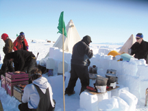
In one of the coldest parts of the world, four Sandia researchers recently took advantage of what is considered to be one of the warmest time of the year in Antarctica late last year.
At peak temperatures of 35 degrees outside with the sun shining continuously, the researchers worked diligently on a highly planned project. There was no room for error or equipment failures because there is no overnight express to Antarctica.

The goal of the mission was to test a Sandia-modified miniaturized synthetic aperture radar (MiniSAR) prototype sensor that could detect buried or bridged crevasses for the New York Air National Guard (NYANG). Flying for the National Science Foundation, the Air Guard must land planes safely in this remote area of Antarctica. The use of
the Sandia sensor would augment or replace the present method of manually finding the crevasses.
“We were highly successful in demonstrating our ability to detect snow-covered crevasses in Antarctica using Sandia’s MiniSAR crevasse detection radar,” says Tim Mirabal (5341), project manager.
The Antarctica team, led by Grant Sander (5342), included Jeff Bradley (5338), Doug Bickel (5354), and Jeffrey Bach (5345). The team left on Thanksgiving Day 2006 and stayed there for nearly three weeks.
Technical homework
Sandia began working on the crevasse detection radar (CDR) in March 2006 when funding was received from New York Air National Guard to create a system using Sandia’s existing MiniSAR technology.
The first step was to change the normal KU-band frequency to X-band. KU-band frequency is 12 to 18 GHz and X-band frequency is 8 to 12 GHz. A lower frequency was needed to penetrate the snow. The snow in Antarctica is unique in the world as it is very dry; whether the radar would perform as well in other climates would need to be investigated, says Tim.
The team built an external X-band converter and changed the front-end components as well. New engineering had to be done in order to accommodate the X-band frequency.
A gimbal arm and electronics were redesigned to allow free movement and antenna balance. The design had to allow for easy assembly and disassembly, says Grant.
“We were able to grow the gimbal assembly and make it perform better,” says Tim. “This included rerouting the wiring.”
In addition, the team developed specifications for data formats, mechanical and electrical components for installation on the plane, and software tools to review the data.
The technical design team, consisting of more than 30 Sandians, worked for 10 months to meet the objectives of the project. The team built two systems, with one serving as a backup.
“Being that far away, it was good to have a complete spare in your back pocket,” says Grant.
Jeffrey Bach, who served as hardware specialist on the trip, says there also was a potential interference problem from the radar system, but the solution didn’t arrive in time to apply it before shipping the radar.
“Luckily, my skills weren’t needed, as the hardware performed well,” says Jeffrey. “I made myself useful in other ways, such as helping to retrieve radar targets from the field at midnight, with the sun still shining brightly.”
Road to Antarctica
The hidden crevasse problem was first brought to Sandia’s attention in 1999 when the Guard needed assistance in locating deep cracks in the ice. The crevasses made it difficult and dangerous to land airplanes. Historically, millions of dollars have been lost due to crevasse-related incidents. Not until Sandia developed the MiniSAR could the Guard afford to demonstrate CDR technology.
The NYANG uses the LC-130 aircraft, which has special landing gear, to operate off the snow and ice at McMurdo Station, Antarctica’s largest community. McMurdo is built on the bare volcanic rock of Hut Point Peninsula on Ross Island, the farthest south solid ground accessible by ship. McMurdo, established in 1956, has grown from an outpost of a few buildings to more than 100 structures including a harbor, an outlying airport with landing strips on sea ice and shelf ice, and a helicopter pad. There are above-ground water, sewer, telephone, and power lines linking buildings. During the winter about 200 to 400 people work at McMurdo, swelling to some 1,500 people in the summer.
The team flew commercial airlines from Los Angeles to Auckland, New Zealand, then on to Christchurch, New Zealand. From Christchurch they took an eight-hour military LC-130 flight to McMurdo.
Before arriving at McMurdo the researchers underwent numerous and extensive physical and dental exams. Each team member had a backup who also went through the rigorous exams as if they were going. They included Marty Thompson (5348), Mike Pedroncelli (5338), Tim Bielek (5342), Steve Reber (5342), Phil Kahle (5334), and Mike Taylor (5342).
At Christchurch they were fitted for extreme cold-weather gear and upon arrival at McMurdo they participated in a two-day “Snow Craft 1” boot camp — also known as “happy camper school.” The camp prepared the team on what to expect and taught them various safety and survival techniques.
The hunt for crevasses
“Most people don’t realize how large Antarctica is because of it being at the bottom of the globe,” says Grant. “This is the area that the Guard is dealing with when it comes to the remote sites that they need to supply.”
The crew collected data in several locations including McMurdo Station, Pegasus Wreck, Shear Zone (Mina Bluff Area), Shear Zone Traverse, and Taylor Dome.
“First we mapped McMurdo, Scott Base, and the nearby pressure ridge. Then we flew the Pegasus Wreck site, where our corner reflector array and junk pile were located, says Jeff, who served as test planner, motion measurement operator while flying on the aircraft, morale officer, and snow shovel operator.
Data was sent from the detection radar to an office at McMurdo where Doug served as on-ground support analyst.
Doug pieced the data together to create coherent maps of the surveyed areas. “Piecing the data together using software was a difficult task,” Doug says. “But the software was able to receive high volumes of data.”
On one day, the researchers were able to conduct two flights while mapping two 5- by 5-nautical mile areas. The 5- by 5-mile area was a goal set by the Guard to find a suitable spot to land in the vicinity of a remote camp.
“We saw crevasses from the first patch of radar data onward,” Jeff says. “The first area was at the Shear Zone, an area where multiple glaciers come together and flow in parallel. There is a road bladed into it, an attempt to build a road to the South Pole. It has not been maintained this year, but we think we saw it anyway in the radar data. This couldn’t be seen by the naked eye.”
The “Tres Hermanas” crevasses, selected by Guard customers Maj. Mark Armstrong and Maj. Walter Hallman, were studied closely. The three crevasses are difficult to visualize from the air and are located in a fairly flat area that represents a possible location to land LC-130 aircraft. The Tres Hermanas are relatively narrow — around four meters wide — and are covered with a snow bridge. Loose snow blows across and camouflages the crevasse, making it look like all the other terrain, especially from the air. The bridge in these crevasses is very loose snow and only a couple meters deep.
“Maj. Armstrong, who is also an LC-130 pilot, was thrilled that we could detect these crevasses using the CDR, especially because of their size and the difficulty in seeing them from the air,” says Tim.
CDR outcomes
“The Antarctica MiniSAR CDR can identify hidden threats, clearly show hazards, and effectively covers large areas,” says Tim.
“The efficacy of the sensor for this application has now been proven,” Jeff says. “I hope the project has the opportunity to carry forward to a fully fieldable system that the Guard can use to make its job of supplying the remote camps and conducting emergency operations safer and more efficient.”
Another successful part of the trip was gathering radar imagery of Antarctica, says Jeff.
“We experienced excellent weather, infinite visibility, and fantastic scenery,” Jeff says. “And of course cool SAR imagery.”
CDR outlook
Since Sandia has successfully demonstrated the ability to see buried crevasses, the team continues to work to sell the capability and secure funding to begin the integration of the CDR on the LC-130 aircraft.
Funding has been set aside to begin analyzing the data obtained in Antarctica and start addressing the integration activity.
“Integration will be a challenge as a lot of work is still necessary to make the CDR ruggedized and user friendly, but we’re up for the task,” says Tim. “The MiniSAR CDR has other applications, such as day or night search and rescue, a capability the Guard needs. And we will continue to assist them.” Michael Padilla
Arctic dreams
Growing our understanding of climate change

(Click on the image at right to launch a PDF version of this story)
On the cold tundra near the Arctic Ocean in northern Alaska, researchers from around the world are transforming scientists’ under-standing of what the future may hold for the Earth’s climate.
Located just east of Barrow along the coast of the Chukchi Sea, the North Slope of Alaska (NSA) site’s unique location provides researchers with a rare, ground-based window into the cloud and radiative processes that take place in the earth’s atmosphere at high latitudes. The research performed here has resulted in NSA arguably being today’s most successful atmospheric research program.
“What makes the North Slope site important is that climate processes differ depending on where on Earth they occur,” says Bernie Zak (6338), science liaison for the North Slope site. “At the North Slope and in other cold regions, different processes are important because water there is mostly in solid, rather than liquid, form.”
Sponsored by DOE’s Office of Science and managed by its Office of Biological and Environmental Research, NSA is one of three global locales operated by the Atmospheric Radiation Measurement (ARM) Program’s national user facility for interdisciplinary studies of earth systems, the ARM Climate Research Facility (ACRF). Along with sites in the US southern Great Plains and the tropical western Pacific, these primary, fixed locations are equipped with an extensive array of instruments for obtaining atmospheric data. In 2005, the ACRF added a mobile facility to its suite of research capabilities.
“Using a closely integrated team of national laboratory partners, the ACRF provides the complex physical infrastructure and data systems needed for national and international research efforts related to global climate change,” says Mark Ivey (6338), NSA site manager for the ACRF. “We provide the facilities, support, and atmospheric measurement data for an international group of scientists. At the NSA, we’ve also been incredibly fortunate in receiving the support of native Inuit — what we call Eskimo — communities in the vicinity of the site.”
Researchers on ice
Extending south to the vicinity of Atqasuk, west to Wainwright, and east toward Oliktok, the extended NSA locale has become a modern-day center for atmospheric and ecological research activity. These high latitudes are receiving increased attention by climate researchers as they work to better understand the interactions of the atmosphere-land-ocean system. The Arctic, specifically, is predicted to undergo more intense warming than any other region on earth because water undergoes a specific seasonal phase change there. Scientific evidence indicates, in fact, that this warming is already happening.
“The arid cold during winter at the North Slope provides a ‘window’ into space,” says Bernie. “Under these conditions, infrared radiant energy can escape more easily through the atmosphere — it’s something that’s part of the earth’s natural energy balance. This is one of the ways that high latitudes are quite different from temperate or tropical regions, and reinforces the importance of our research here.”
The value of these different regional factors is that the researchers have the chance to study how longwave energy gets trapped to varying degrees inside the atmosphere by different conditions from chemical constituents that include water vapor, carbon dioxide, methane, nitrous oxide, chlorofluorocarbons, and liquid water droplets that absorb the energy emitted by the surface of the Earth.
“Essentially, our work at these facilities enables us to contribute to improvements in climate models that simulate global climate change,” Bernie says.
Such global climate models are tools for calculating atmospheric, land, and oceanic conditions all over the earth. By providing cloud and radiative transfer information to climate modelers, say Bernie and Mark, the site’s data will help to improve the performance of general-circulation and related models of the atmosphere as tools for predicting future global and regional climate changes.
“Because the North Slope site is fairly cold year-round, we often observe clouds that are composed of ice or ice and water in mixed phases,” says Mark. “In 2004, the ACRF sponsored a field experiment to specifically study mixed-phase clouds in the arctic. The results of the Mixed-Phase Arctic Cloud Experiment — or MPACE — have changed our understanding of arctic clouds and how they should be represented in climate models.”
“Our high-latitude NSA location also allows researchers the opportunity to study surface optical properties with and without snow and/or ice cover as a function of temperature history,” says Bernie. “Snow and ice surfaces are more reflective to visible light than soil or vegetation, and that plays an important role in high latitude and global climate.”
A strong indicator of the value of the site’s work is the number of researchers who make use of the data obtained there. Academic, foreign, domestic, and other researchers from many different areas of research use data collected from the NSA. Many also come to the site for field campaigns to temporarily add their own unique measurement capabilities to the existing instrumentation suite and study specific phenomena.
“People are still publishing peer-reviewed articles based on the 2004 MPACE data,” says Bernie. “We found far fewer ice nuclei than had been expected — that is, far fewer aerosol particles capable of nucleating ice crystals. This means that water was staying liquid even at very low temperatures. That has direct implications, not only for climate, but for the Federal Aviation Administration as well, because when this liquid water comes into contact with planes, it instantly converts to ice. These icing conditions can bring down aircraft.”
“Our work isn’t just limited to climate research,” says Mark. “The Army has done research on the atmospheric phenomena that cause the twinkling of the night sky, and how distant objects can be seen more easily through the atmosphere at certain times of the day, under certain meteorological conditions. Our location and instruments at the North Slope provide data sets that are useful to a wide range of research interests. That is one of the reasons the NSA locale was chosen as part of the ACRF.”
At the end of a hard day of work, Bernie and Mark say the thing they’re most grateful for is the caliber of the team members they work with.
“The NSA is a cold place with a lot of equipment and little in the way of creature comforts — without guys like Jeff Zirzow (6338), and our local native technicians, Walter Brower and Jimy Ivanoff, I don’t know how we’d get anything done,” says Mark.